Ashby museum has an archive of over 3000 photographs – both original and copies. This page allows people to view the main group of photographs, but does not include photographs in specialist collections as these often include ones that are not in our primary area of interest. Larger images may be viewed at the museum during opening hours, and copies for private use may be purchased.
This page also allows access to details of artefacts (physical objects) held by the museum. Please note that when changing between photographs and artefacts, the classification list is only updated after the first search.
Showing images 1911 to 1920 of 4081
AYZMU:P12-0558
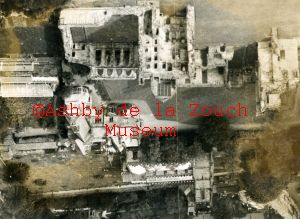
1940 - 1945 circa
Enlarged section of previous photo. showing St. Helen's church and castle. 1940's approx.
AYZMU:P12-0557
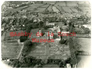
1940 - 1945 circa
Aerial photo looking north. Castle in centre. 1940's approx. Photo dated by fact that some buildings known to have been demolished in the 1950's are still visible.
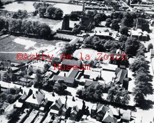
AYZMU:P12-0556
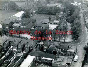
1960 - 1969
Aerial photo looking south west over Leicester Road. Cottage hospital at bottom of photo, complete with maternity wing. Boys Grammar School in centre. Castle, St. Helen's church and Manor House, just visible at top.
AYZMU:P12-0555
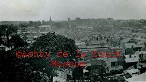
1890 - 1900
Aerial photo of Ashby, probably taken from tower of St. Helen's church. Trinity church, with spire visible in distance, therefore photo is pre 1900
AYZMU:P12-0554
1935 - 1940
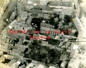
Aerial photo of west side, lower end of Market Street, area between Market Street and South Street. Note all the courtyard buildings. Vehicles visible in Market Street by island would indicate photo is pre WW11.
AYZMU:P12-0553
1962
Aerial photo in 1962, of castle (at top of photo), with St. Helen's church to the right. Manor House and Boy's Grammar School, with Leicester Road across lower part of picture left to right, with Cottage Hospital extreme lower right.
AYZMU:P12-0552
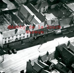
1977 - 1980
Aerial photo of Market Street, with old Ison's premises boarded up - later occupied by Boots (chemists) and Preedy's (newsagents) which then became W.H.Smith. Next right are: Hammonds (butchers), Leicester Building Society, Alec Small (jewellers), Close Nurseries, and Rushtons. Note demolition taking place behind Ison's premises and dwellings still visible in what is now Rushton's yard.
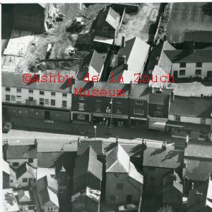
AYZMU:P12-0551
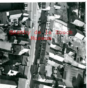
1977 - 1980
Aerial photo of Market Street, with old Ison's premises boarded up - later occupied by Boots (chemists) and Preedy's (newsagents) which then became W.H.Smith. Next right are: Hammonds (butchers), Leicester Building Society, Alec Small (jewellers), Close Nurseries, and Rushtons. Note demolition taking place behind Ison's premises and dwellings still visible in what is now Rushton's yard.Just to right of Rushton's can be seen Quick Save (supermarket) - now New Look (ladies clothing). To left of Ison's, can see J. Stone (fruiterers) and Richards (electrical) at end of island).
AYZMU:P12-0550
1977 - 1980
Aerial photo of Market Street, with old Ison's premises boarded up - later occupied by Boots (chemists) and Preedy's (newsagents) which then became W.H.Smith. Next right are: Hammonds (butchers), Leicester Building Society, Alec Small (jewellers), Close Nurseries, and Rushtons. Note demolition taking place behind Ison's premises and dwellings still visible in what is now Rushton's yard.
AYZMU:P12-0549
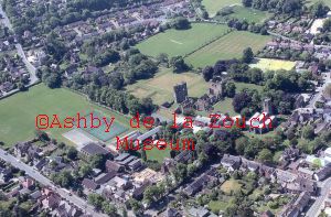
5.2010
Aerial photo of mostly the north end of the town in May 2010, viewed from South West. Castle, St. Helen's church, Manor House etc. and Ashby School playing fields in centre of picture with Mount Walk between.