Ashby museum has an archive of over 3000 photographs – both original and copies. This page allows people to view the main group of photographs, but does not include photographs in specialist collections as these often include ones that are not in our primary area of interest. Larger images may be viewed at the museum during opening hours, and copies for private use may be purchased.
This page also allows access to details of artefacts (physical objects) held by the museum. Please note that when changing between photographs and artefacts, the classification list is only updated after the first search.
Showing images 2821 to 2830 of 4081
AYZMU:P10-1069
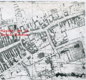
1945 (pre)
Plan of central Ashby. Top right is the brow of top of Wood
Street and Nottingham Road, just after site of the former
Pattern (public house). No semi detached houses are featured -
which were built just after 1945.
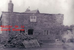
AYZMU:P10-1068
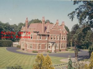
1960 - 1965
The Red House, off Upper Packington Road. Was owned by The Red
Bank Manufacturing Co. Ltd. and sold by Stevenson and Barratt.
Building demolished and the site redeveloped into St. Michaels
Close in the late 1960's.
AYZMU:P10-1067
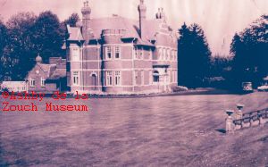
1960 - 1965
The Red House, off Upper Packington Road. Was demolished and the site redeveloped into St. Michaels Close in the late 1960's. Also a series of photos taken in 1964: 4. Living room with Mrs Florence Saunders seated 5. House from terrace. 7.Front door and drive 8. Terrace in bloom 9. Looking from house to terrace and summer house. 10. View from house towards Upper Packington Road 11. Hallway, Mr E.H. Saunders standing on stairs. 12. Looking from raise terrace 13. Dining room
AYZMU:P10-1066
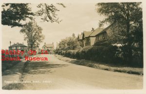
1950 - 1955
Upper Packington Road looking towards Leicester Road from
entrance to Mount Walk. Car would date photo to around 1950's.
AYZMU:P10-1065
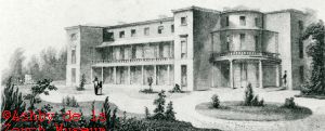
1800 - 1850
Wrights engraving of Prior Park House. "These are new and
handsome buildings erected in an elevated and healthy situation
near the castle. They command a good view of the baths and
pleasure grounds.
AYZMU:P10-1064
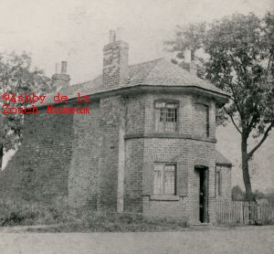
1900 (circa)
Leicester Road toll house, which stood on right as one turned
left into Corkscrew Lane outbound from Ashby. Dick Britain lived
here in approx 1900. Census information indicates in 1871, Jane
Wright (widow) lived there, whose daughter Catherine, married
Joseph Curtis, gamekeeper at Alton Grange.
AYZMU:P10-1063
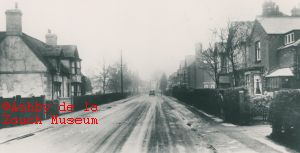
1920 - 1939
Leicester Road with Grammar School on left, and Cottage hospital
on right at end of terrace of houses. Similar view to P10-1062.
As long ago as 1930's, plans existed to carry the road straight
on to Nottingham Road, rather than take a sharp left turn to
skirt the Grammar school. Car would indicate date of between
1920 to late 1930's.
AYZMU:P10-1062
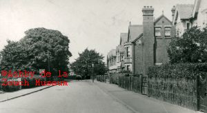
1930 - 1935
Leicester Road in probably the 1930's, with site of Grammar School on left, and Cottage hospital on right, out of sight, at end of terrace of houses. House with chimney built 1900 and adjacent houses in the 1920's.
As long ago as 1930's, plans existed to carry the road straight on to Nottingham Road, rather than take a sharp left turn to skirt the
Grammar school.
AYZMU:P10-1061
1920 - 1930
Mount House, Leicester Road. Also known as the "Irish Fort" - a
regiment of Irish soldiers were billeted there at some stage.
This triangular building is 200 yards east of the castle, and so
called because of the earth mounts which surrounded it. Was
erected to give the guns of the Royalists a sufficiently
elevated position to reach the fort of the Parliametarians at
Coleorton, some two miles away.
AYZMU:P10-1060
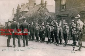
1920 - 1930
Parade outside Cottage hospital. Miltary and Boy Scouts
standing on Leicester Road. The three gentlemen in charge of
parade are left to right: S.M.Tucker, Captain T.E.Jesson and Lt.
Col G. German. A young boy, extreme right front, in the Scouts
is identified as "Guy".